

Explore the 6 best hiking websites in 2027. Compare useful platforms for trail discovery, hiking maps, route planning, and outdoor adventures.
Looking for the best hiking websites in 2027 to plan your next outdoor adventure? The right hiking apps and trail-planning websites can make your journey easier, safer, and more enjoyable. Whether you’re a beginner exploring local trails or an experienced hiker planning long-distance adventures, choosing the right tools is important. In this guide, we’ll explore 6 best hiking websites, including HiiKER, Komoot, Gaia GPS, Windy, PeakFinder, and Merlin Bird ID. Compare their features, navigation tools, offline maps, and benefits to find the perfect hiking companion for your next adventure.
Hiking Website Comparison
| Hiking Website | Best For | Free Access | Main Features | Best Advantage |
|---|---|---|---|---|
| HiiKER | Hiking maps and route planning | Free plan available | Offline maps, GPS tracking, GPX routes | Best for long-distance hiking |
| Komoot | Easy route planning and navigation | Free first region | Voice navigation, route planning, elevation profiles | Best for beginners |
| Gaia GPS | Advanced GPS navigation | Free plan available | Topographic maps, satellite maps, waypoints | Best for experienced hikers |
| Windy | Hiking weather forecasts | Free version available | Wind, rain, temperature, weather maps | Best for weather updates |
| PeakFinder | Identifying mountain peaks | Paid app | 360° mountain views, peak identification | Best for mountain exploration |
| Merlin Bird ID | Identifying birds during hikes | Completely free | Bird sound recognition, photo identification | Best for nature lovers |
1. HiiKER – Best for Hiking Maps and Route Planning
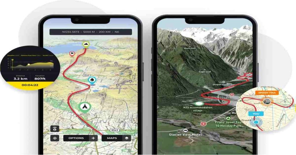
Best For: Hikers who want detailed topographic maps, offline navigation, and multi-day route planning.
HiiKER is one of the best hiking apps which will be beneficial for people who enjoy exploring hiking trails, mountains, and long-distance hikes. The main benefit of this app is that it gives you access to a variety of hiking maps that will help you better understand the area and trails you plan to explore.
The major advantage of this app is its offline availability. You can download maps of hiking trails beforehand because it might happen that there will be no mobile network in the place you are going to visit. Also, HiiKER app provides GPS tracking and importing and exporting GPX routes and elevation.
Key Features:
- Topographic and outdoor maps;
- Offline map downloading;
- GPS hiking tracking and route recording;
- GPX import/export;
- 3D terrain visualization;
- Planning of multi-day hiking routes;
| Advantages | Disadvantages |
| Provides a variety of hiking maps. | Some features can only be used after subscribing. |
| Can be used offline. | It may take time for beginners to learn all the tools. |
| Useful for planning multi-day hikes. | Availability of maps differs from region to region. |
| Has GPS and GPX tools. | The quality of some map overlays can be better. |
Pricing: Free plan available; HiiKER PRO+ starts at approximately $7.37/month or $20.99 for the first promotional year, with regular annual pricing varying by offer.
2. Komoot – Best for Route Planning and Navigation
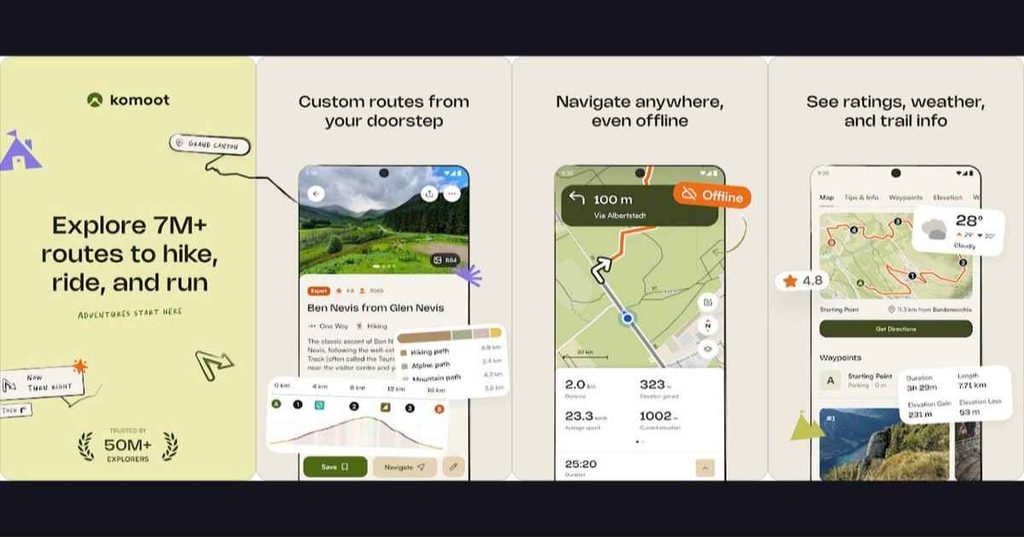
Best For: Hikers, cyclists, and outdoor enthusiasts who want simple route planning and turn-by-turn navigation.
Komoot is a universal navigation app that is aimed at helping people who enjoy hiking, cycling, mountain biking, and other outdoor sports. The user can make routes depending on the type of sport he or she chooses and can choose interesting tracks among the suggestions of the community. The simple interface makes it easy for beginners to plan the routes.
One of the main advantages of the app is turn-by-turn voice navigation. The hiker does not need to pay attention to the screen of the phone, as he or she can listen to the instructions and follow the chosen track. The user can use offline maps, elevation profile, information about the landscape and surface. At first, users have access to one free region and can buy other maps or choose the Premium version.
Key Features:
- Custom hiking route planning.
- Turn-by-turn voice navigation.
- Offline maps for unlocked regions.
- Elevation profiles and terrain information.
- Community trail recommendations.
- Route synchronization with compatible devices.
| Advantages | Disadvantages |
| Easy-to-use interface for route planning. | Payment for other regions. |
| Suitable for various outdoor activities. | Premium features for certain functions. |
| Voice navigation. | Quality of the routes depends on the community. |
| Recommendations of the community. | It is not specialized in topographic maps compared to some competitors. |
Pricing: Free first region; Single Region approximately $3.99, Region Bundle $8.99, and World Pack $29.99 (one-time purchases, US pricing).
3. Gaia GPS – Best for Advanced GPS Navigation
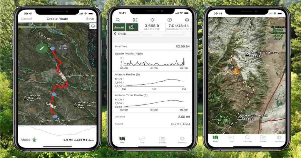
Best For: Experienced hikers, backpackers, and outdoor explorers who need advanced GPS mapping tools.
The Gaia GPS is an excellent application that allows you to navigate with maps and routes when hiking. It will be really helpful when traveling in the backcountry, in distant locations, and in places where other applications have not enough geographic information. There are different types of maps in this app including topographic, satellite, and terrain maps.
Moreover, there are GPS tracking and waypoints options in the app. You can track your journeys, create some waypoints and routes on detailed maps. The premium subscription gives you access to downloading maps and a bigger variety of maps. Thus, the application can be recommended to those hikers who like discovering new places.
Key Features:
- Advanced topographic maps.
- Satellite and terrain map layers.
- GPS route recording.
- Waypoint creation and management.
- Offline map downloads with Premium.
- Slope-angle and elevation-related overlays.
| Advantages | Disadvantages |
| Customization of maps. | Complicated interface for beginners. |
| Backcountry-friendly. | Maps downloading in offline mode requires Premium subscription. |
| GPS tracking. | Advanced options require some time to learn. |
| Useful terrain and satellite layers. | Specialized layers depend on the region. |
Pricing: Free plan available; Gaia GPS Premium approximately $59.90/year in a US App Store listing, with regional and promotional variations.
4. Windy – Best for Hiking Weather Forecasts
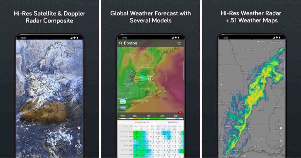
Best For: Hikers who want detailed weather forecasts, wind information, and changing outdoor conditions.
Windy is a weather application and may be helpful for those people who love hiking and other outdoor activities. Weather conditions can change suddenly in the mountains, so it is necessary to keep in mind such factors as wind speed, rain, clouds, and temperature before going for hiking. This application gives an opportunity to its users to get acquainted with the weather conditions with the help of weather maps and forecasts.
This application gives its users the possibility to have access to various weather forecast models and compare them. Moreover, it gives information about wind, precipitation, temperature, and other weather conditions. Even though this application is not a hiking navigation one, it may help hikers in making decisions about the right time and place for hiking. It is especially useful for planning mountain hikes or taking pictures outside.
Key Features:
- Interactive weather maps.
- Wind speed and direction forecasts.
- Rain and precipitation information.
- Temperature and cloud forecasts.
- Multiple weather forecasting models.
- Detailed weather visualization.
| Advantages | Disadvantages |
| Detailed information about the weather conditions. | Is not a hiking navigation application. |
| Helps to monitor the changes in the wind. | Advanced weather forecast models are Pro only. |
| Interactive weather maps. | May be complicated for beginners. |
| Helpful for many outdoor activities. | Not always accurate predictions. |
Pricing: Free version available; Windy.app PRO approximately $64.99/year or $109.99 for a lifetime offer on its published US pricing page.
5. PeakFinder – Best for Identifying Mountain Peaks

Best For: Mountain hikers and travellers who want to identify surrounding mountains and peaks.
PeakFinder is an unique application aimed at helping the user to find mountains and peaks around him. While hiking in unknown mountain territories, it would be interesting to know what mountains are named and located nearby. With the help of PeakFinder, you will be able to see the panorama of the territory and the names of the mountains.
The application uses the location, compass, and motion sensors of the device to display the mountains around. PeakFinder contains a great database of mountains all over the world and works offline. This feature makes it really helpful while hiking in remote mountain territories. But it cannot replace a navigation application with such functions as route planning and navigation. Nevertheless, it adds educational and entertaining elements to the process of mountain hiking.
Key Features:
- 360-degree mountain panorama.
- Mountain and peak identification.
- Offline worldwide peak database.
- Camera-based panorama visualization.
- Digital telescope functionality.
- Sun and moon path information.
| Advantages | Disadvantages |
| Recognizes more than one million mountain peaks. | Cannot be used for route planning purposes. |
| Works offline all over the world. | It is not a navigation application for hiking. |
| Convenient way of learning the names of mountains. | Needs compass and motion sensors for some features. |
| Great panoramic view experience. | Needs to purchase the application. |
Pricing: Approximately $4.99 one-time purchase on the US App Store; no recurring subscription is listed.
6. Merlin Bird ID – Best for Identifying Birds During Hikes

Best For: Nature lovers, birdwatchers, and hikers who want to identify birds using photographs and sounds.
Merlin Bird ID is a wonderful application for those who enjoy observing wildlife when they hike or perform other outdoor activities. This application was created by Cornell Lab of Ornithology, and it helps in identifying bird species using photos, sounds, and identification questions. So Merlin Bird ID will be very helpful for those people who would like to know more about the birds they observe during their hikes.
The most fascinating feature of this application is that it allows identifying birds using Sound ID feature, which helps in bird identification based on their sounds. Photo ID allows identifying birds based on photos. One can download regional bird packs to identify birds in different regions. Although Merlin Bird ID is not a hiking navigation application, it gives educational experience while hiking.
Key Features:
- Bird identification through photographs.
- Bird sound recognition.
- Regional bird information packs.
- Species information and photographs.
- Bird identification through guided questions.
- Educational wildlife information.
| Pros | Cons |
| The application is totally free to download and use. | The application is not a hiking navigation application. |
| The application is useful for bird identification while hiking. | Accuracy of bird identification can differ. |
| The application provides photo and sound identification. | Regional bird packs should be downloaded. |
| The application provides educational information about birds. | Good audio/picture quality is required. |
Pricing: Completely free; no subscription or credit card required.
How to Choose the Best Hiking App?
Choosing the best hiking app depends on your experience, budget, and hiking needs. Consider these important factors before selecting one:
- Easy Navigation: Choose an app with simple maps and GPS tracking.
- Offline Maps: Look for apps that work without an internet connection.
- Route Planning: Check whether the app offers trail details and elevation profiles.
- Weather Updates: Choose tools that provide reliable weather information.
- Pricing: Compare free features and paid subscription plans.
- Extra Features: Look for GPS tracking, mountain identification, and safety features.
Useful Tips for Using Hiking Apps Safely
Download Offline Maps: Download maps and routes before starting your hike.
Check Trail Conditions: Check weather, reviews, and trail warnings.
Carry Backup Navigation: Keep a paper map and compass.
Share Your Plans: Inform someone about your route and return time.
Save Battery: Fully charge your phone and carry a power bank.
Choose the Right Trail: Select a trail according to your fitness and experience.
Respect Nature: Follow trail rules, protect wildlife, and avoid littering.
Best Hiking Apps for Android and iPhone
Most popular hiking apps support both Android and iPhone, making trail discovery, route planning, and GPS navigation easy across devices.
Apps like AllTrails, Komoot, HiiKER, Gaia GPS, and Outdooractive offer useful features such as offline maps, GPS tracking, and trail recommendations. OS Maps is great for exploring Great Britain, while Windy helps check weather conditions.
Before downloading, check app availability, pricing, and whether features like offline maps and advanced navigation require a premium subscription.
Can You Use Two or More Hiking Apps Together?
Yes! Using multiple hiking apps together can make your outdoor adventures easier and safer. For example, use Komoot for route planning, Gaia GPS for navigation, and Windy for weather updates.
Combining these apps helps you plan better routes, track your location, and stay prepared for changing weather conditions.
Conclusion
Choosing the best hiking website depends on your outdoor adventure needs, experience level, and navigation requirements. Each platform offers different features to make hiking and trail planning easier.
HiiKER is an excellent choice for long-distance hiking and offline maps, while Komoot is ideal for beginners who want simple route planning and voice navigation. Gaia GPS is better suited for experienced hikers who need advanced GPS navigation and detailed topographic maps. If checking weather conditions is your priority, Windy is a useful option.
Similarly, PeakFinder is great for identifying mountain peaks, and Merlin Bird ID is a helpful companion for nature lovers and birdwatchers.
Overall, there is no single hiking website that works best for everyone. Compare the features, pricing, and navigation options of these six platforms before choosing the one that matches your hiking needs. With the right tools, you can plan your routes more confidently and enjoy safer, more organized outdoor adventures.
Frequently Asked Questions
1. What is the best hiking website in 2027?
Komoot, HiiKER, and Gaia GPS are popular choices for hiking route planning and navigation.
2. Which hiking app is best for beginners?
Komoot is a good option for beginners because of its easy navigation and route-planning features.
3. Can I use hiking apps offline?
Yes! Apps like HiiKER and Gaia GPS offer offline map options, depending on the plan.
4. Are hiking apps free to use?
Many hiking apps offer free versions, but some advanced features require paid subscriptions.
5. Which hiking app is best for GPS navigation?
Gaia GPS is a popular choice for detailed GPS navigation and topographic maps.
6. Can I use two or more hiking apps together?
Yes! You can combine Komoot, Gaia GPS, and Windy for route planning, navigation, and weather updates.
7. Which app is best for checking hiking weather?
Windy is useful for checking wind, rain, temperature, and weather forecasts.
8. Do hiking apps work without the internet?
Some do! Download offline maps before your hike to navigate in areas with poor network coverage.
9. Which hiking app is best for identifying mountains?
PeakFinder helps identify surrounding mountain peaks using panoramic views.
10. Are hiking apps useful for long-distance hiking?
Absolutely! Apps like HiiKER and Gaia GPS help hikers explore trails, track routes, and prepare for longer adventures.